Geography: 2017: CBSE: [All India]: Set – I
To Access the full content, Please Purchase
-
Q1
State the two groups of factors which affect the profitability of mining.
Marks:1View AnswerAnswer:
The profitability of mining depends upon several factors such as
i) Richness or Grade of the Ore
ii) Size of Deposit
iii) Method of Mining, etc.
-
Q2
Which country of the world has the highest road density?
Marks:1View AnswerAnswer:
Japan has the world’s highest road density i.e. 327 for every 100 square kilometer.
-
Q3
Name any two garrison (cantonment) towns of India.
Marks:1View AnswerAnswer:
The two garrison (cantonment) towns of India are Ambala and Jalandhar.
-
Q4
Why is West Asia the least developed in rail facilities? Explain on reason.
Marks:1View AnswerAnswer:
West Asia is least developed in rail facilities because of vast deserts and sparsely populated regions.
-
Q5
Examine the twin environmental problems that have emerged in the ‘Indira Gandhi Canal Command Area’.
Marks:1View AnswerAnswer:
Water logging and soil salinity are the problems that have emerged in the ‘Indira Gandhi Canal Command Area’.
-
Q6
Classify minerals on the basis of chemical and physical properties.
Marks:1View AnswerAnswer:
On the basis of chemical and physical properties minerals can be divided into metallic and non-metallic minerals.
-
Q7
How can you help in improving the quality of water in your locality?
Marks:1View AnswerAnswer:
We can practise rainwater harvesting to improve the quality of water as it dilutes the contaminants like fluoride and nitrates.
-
Q8
Study the map given below carefully and answer the questions that follow:
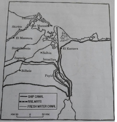
(11.1) Identify and name the canal shown in the map.
(11.2) Write any four characteristics of this canal.
Note: The following question is for the Visually Impaired Candidates only, in lieu of Q. No. 11.
Which canal connects two oceans? Write any four characteristics of that canal.
Marks:3View AnswerAnswer:
11.1 Suez Canal is shown in the map.
11.2 The characteristics of Suez Canal are:
(i) It links the Mediterranean Sea and the Red Sea.
(ii) It lies between Port Said in the north and Port Suez in the south.
(iii) It is a sea-level canal without locks.
(iv) The tolls are so heavy that many ships find it cheaper to go through the longer Cape Route.
Answer for visually impaired candidates’ question:
Suez Canal connects Atlantic Ocean and Indian Ocean. More precisely, it connects Mediterranean Sea and Red Sea. Four characteristics of this canal are:
(i) It links the Mediterranean Sea and the Red Sea.
(ii) It lies between Port Said in the north and Port Suez in the south.
(iii) It is a sea-level canal without locks.
(iv) The tolls are so heavy that many ships find it cheaper to go through the longer Cape Route.
-
Q9
Describe any three characteristics of chain stores in the world.
Marks:3View AnswerAnswer:
Important characteristics of chain stores in the world are as follows
i) The purchase merchandise most economically to their specification.
ii) They often direct the manufacturers.
iii) They employ highly skilled specialists.
iv) They have the ability to experiment in one store
-
Q10
Study the diagram given below and answer the questions that follow:
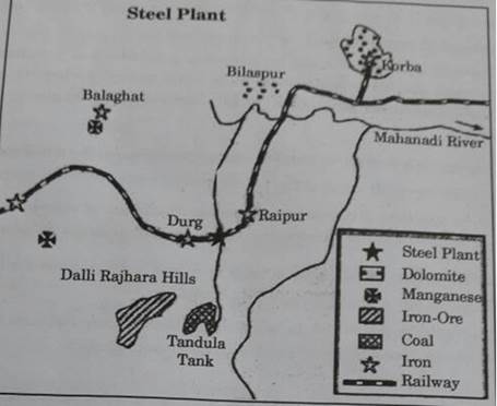
(12.1) Identify and name the steel plant given above. In which state is plant located?
(12.2) Which is the main source of power for this steel plant? Which rail route provides transport facilities to this plant?
(12.3) What are the major sources of iron-ore and water for this steel plant?
Note: The following question is for the Visually Impaired Candidates only, in lieu of Q. No. 12:Explain any three major factors responsible for the establishment of Tata Iron and Steel industry in Jamshedpur.
Marks:3View AnswerAnswer:
(12.1) Bhilai Steel Plant is shown in the map.
(12.2) Main source of power for this steel plant is Korba Thermal Power Station. Transport facilities are provided by Kolkata-Mumbai rail route.
(12.3) Iron-ore is supplied by Dalli-Rajhara mine and water comes from Tandula Dam.
Answer for visually impaired candidates’ question:
Tata Iron and Steel Industry is located at Jamshedpur, an ideal location for the establishment of Iron and Steel Plant. It gets its iron-ore from Noamundi and Badam Pahar and coal from Joda mines in Odisha, both of which are very close to the city. The rivers Subarnarekha and Kharkai provide water to the plant. It lies on the main Mumbai-Kolkata rail route and is only 240 km away from Kolkata, the nearest port for the export of steel.