Geography: 2006: CBSE: [Delhi]: Set – III
To Access the full content, Please Purchase
-
Q1
Which approach was followed by F. Ratzel and E.C Semple in the study of human geography? State two characteristics of this approach. 1+2=3 Marks:3View AnswerAnswer:
Deterministic approach was followed by F. Ratzel and E.C Semple in the study of human geography. This approach is also known as environmentalism. Two main characteristics of this approach are: 1. According to this approach man is a slave of environmental forces and man is totally influenced by the forces of nature. According to Semple, ‘man is a product of nature’. 2. This approach explains man as an insignificant and helpless creature before the natural forces. -
Q2
How has the nature of mining in the world undergone changes over time? Explain it with three suitable examples from different periods. 3x1=3 Marks:3View AnswerAnswer:
The nature of mining in the world has undergone major changes over time. Some of the major changes are: 1. In early days of the feudal period, mining was carried on mainly by labour from the prisons and slaves. 2. In the middle ages, mining was considered a noble profession. 3. In modern times, mining is no longer a major employer. Mechanisation and technological advancement has increased the efficiency and thus very less workforce is now required in this kind of activity. -
Q3
Distinguish between transport and communication by stating any three points of distinction of each. 3x1=3 Marks:3View AnswerAnswer:
TRANSPORT COMMUNICATION 1. Means of transport are the carriages that transport men and material from one place to another. 1. Means of communication are those means which are helpful in communicating news and information from one person to another sitting thousands of kilometer away. 2. The major modes of transport today are the railways, the roadway, waterways, the airways and the pipelines. 2. Means of communication are posts and telegraphs, telephone, fax, teleprinters, print media, radio, television, wireless and satellite. 3. Means of transport help in the economic development of a country. 3. Means of communication help in awakening masses towards world happenings. -
Q4
‘Iron is the most widely used metal in the world.’ Support the statement with its four suitable qualities. Marks:3View AnswerAnswer:
Iron is the most widely used metal in the world because of the following qualities: 1. It is most durable and malleable metal. 2. It is used to produce other alloys, including steel. 3. Iron is hard, brittle, and fairly fusible. 4. Iron is also known for its strength. -
Q5
Explain any three problems of water resources in India . 3x1=3 Marks:3View AnswerAnswer:
The main problems that are related to water resources are: 1. Problems of Availability: Water resources are in excess in certain regions and deficit in others. The north eastern states of the country have excess water resources. On the other hand, dry areas of Rajasthan face acute shortage of water. Rainfall is concentrated in the short period of rainy season and the major part of the year remains dry. 2. Problems of Utilisation: About 90% of the towns are provided with potable water, and the quality and quantity of water is much below normal. Slums and squatter settlements are practically without any water supply. Rural areas are much worse off with respect to supply of potable water. 3. Problems of Quality: Quality of water is largely deteriorating throughout the country. It has been estimated that about three-fourths of the surface water in India is polluted. Most of the rivers in India are polluted. In fact, the water bodies for long have been treated as dumping grounds. -
Q6
Explain three reasons responsible for the location of sugar mills near the sugarcane producing regions in India . 3x1=3 Marks:3View AnswerAnswer:
The three main reasons responsible for the location of sugar mills near the sugarcane producing regions in India are: 1. Sugarcane is a weight-losing raw material and thus sugar mills are located near the sugarcane producing regions. 2. Sugarcane cannot be stored for long as the loss of sucrose content is inevitable. 3. Also sugarcane cannot be transported to long distances because any increase in transportation cost would raise the cost of production and sugarcane may dry on the way. -
Q7
Study the map given below and answer the questions that follow: 2+1=3
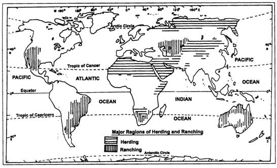
10.1 Name the four major regions of ranching from different continents 10.2 State any two important activities associated with ranching Marks:3View AnswerAnswer:
10.1 Four major regions of ranching are: (i) Pampas in South America (ii) Steppes in Europe (iii) Prairies in North America ; and (iv) Downs in Australia . 10.2 Two important activities associated with ranching are: 1. In ranching number of animals in a pasture is kept according to the carrying capacity of the pasture. 2. Rearing of animals in ranching is organized on a scientific basis. The main emphasis is on breeding, genetic improvement, disease control and health care of the animals. -
Q8
Study the table given below and answer the questions that follow: 3x1=3 Table- India: River Basin-wise Distribution of Usable Surface Water River Basin Annual run-off (bcm) Usable Water (bcm) Storage Capacity (bcm) 1. Indus 73 46 14.52 2. Ganga 501 250 37.40 3. Brahmaputra 537 24 1.09 4. Godavari 119 76 17.27 5. Krishna 68 58 32.23 6. Kaveri 21 19 7.25 7. Pennar 6.8 6.8 2.37 8. Mahanadi 67 50 8.93 9. Brahmani 36 18.1 4.29 10. Sabarmati 3.8 1.9 1.30 11. Mahi 11.8 3.1 4.16 12. Narmada 41 34.5 3.02 13. Tapi 18 14.5 8.68 14. Subarnarekha 10.8 - - Total 1869 690 - 8.1 Name the two major rivers of peninsular India flowing towards east. 8.2 Which of these two rivers has higher storage capacity and state the value of its storage capacity? 8.3 Which one of them has higher value of usable water? State its value also. Marks:3View AnswerAnswer:
8.1
Godavari and Krishna are two major east flowing peninsular rivers
8.2Among these two rivers, Krishna river has higher storage capacity. It is 32.23 bcm
8.3River Godavari has the higher value of usable water. It is 76 bcm. -
Q9
Describe three major components of Green Revolution in India . 3x1=3 Marks:3View AnswerAnswer:
The major components of Green Revolution in India
are:
1. Irrigation: There has been considerable improvement in irrigation in order to shift the focus of the farmers from the monsoon rainfall to the artificial sources of irrigation as the monsoonal rainfall is very irregular.
2. High Yielding Variety of Seeds: Production of certain crops such as wheat, jowar and maize increased considerably with the introduction of HYV seeds. But the introduction of HYV seeds of rice, jowar, maize and bajra has been comparatively low. 
3. Fertlisers and Mechanisation: Fertlisers are an integral component of the Green Revolution. Production and consumption of chemical fertlisers increased rapidly ever since the Green Revolution came on the Indian agricultural scene. 
-
Q10
Study the diagram given below and answer the questions that follow: 3x1=3
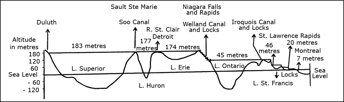
9.1 Name the inland waterway shown in this diagram.
9.2 Name the deepest lake from the sea level and find out its depth from the sea level.
9.3 What is the role of locks in this island waterway? Marks:3View AnswerAnswer:
9.1
In this diagram St. Lawrence inland water way is shown.
9.2Ontario is the deepest lake from the sea level and its depth from the sea level is 120 mts.
9.3Locks in this inland waterway regulate the flow of water as ships have to cross different levels of lakes.