Geography: 2006: CBSE: [All India]: Set – III
To Access the full content, Please Purchase
-
Q1
Which approach was followed by Lucian Febvre and Vidal de la Blache in the study of human geography? Mention two characteristics of this approach. 1+2=3 Marks:3View AnswerAnswer:
Both Lucian Febvre and Vidal de la Blache are the followers of the possiblism. Two major characteristics of this approach are: According to this approach there are no necessities but possibilities everywhere and man as master of these possibilities is the judge of their use. They presented man as an active agent rather than a passive agent.
-
Q2
Explain the properties of three types of coal found in different parts of the world. 3x1= 3 Marks:3View AnswerAnswer:
There are three types of coal found in the world, they are: 1) Anthracite 2) Bituminous and 3) Lignite The major characteristics of these types of coal are as follows: Anthracite coal: This is a very good kind of coal having high amount of carbon content (90%). It is hard and shiny and does not leave ashes after being burnt. Bituminous coal: It is a low grade coal in comparison with anthracite coal. It is having 70-90% carbon content. It gives smoke and ashes when burnt. Lignite coal: It is not black but brown in colour. The carbon content is 45-70% in this type of coal. It gives more smoke when burnt.
-
Q3
How has satellite communication brought revolutionary changes in the field of communication? Explain with three suitable examples. 3x1= 3 Marks:3View AnswerAnswer:
The satellite communication has brought a great change in the field of communication. It can be explained with the help of following points : With the help of satellite technology, day to day climatic data can be easily calculated. Satellite communication has given birth to communication through radio, television and other sources of communication for general people. Satellite communication provides information of the remote areas in digital format.
-
Q4
Define the term ‘intensity of cropping’. Explain two reasons with suitable examples for the uneven distribution of intensity of cropping in India . 3x1= 3 Marks:3View AnswerAnswer:
The amount of crops produced in an agricultural field during an agricultural year is known as intensity of cropping. The intensity of cropping at the national level is 135% in an agricultural year. The uneven distribution of the crops in the agricultural fields can be shown by the following examples: The intensity of cropping is higher in the northern fertile land where alluvial soils are found. These states are Uttar Pradesh, Bihar and West Bengal . On the other hand in Rajasthan and Gujarat, because of arid soil which is not fertile enough, the crop intensity is lesser. Irrigational facilities is another factor that causes uneven distribution of crop intensity in India . Like in U.P, Punjab and Haryana, irrigational facilities causes high crop intensity and in Gujarat and Rajasthan the intensity is low.
-
Q5
Distinguish between thermal electricity and hydroelectricity by stating three points. 3x1= 3 Marks:3View AnswerAnswer:
Differences between thermal electricity and hydroelectricity are as follows: Thermal Electricity Hydroelectricity 1. Thermal electricity is generated by coal and natural gas. 1. Hydroelectricity is generated by water. 2. It produces pollution in the form of smoke while burning. 2. It is a pollution free source of energy and does not generate pollution while it is used. 3. It is an exhaustable source of energy which means it can be used at a limited extent. 3. This is a non-exhaustable source of energy. -
Q6
Study the map given below and answer the following questions: 1+2=3
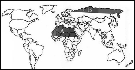
10.1 Name the two major regions of herding marked in the map by A and B.
10.2 Explain the main reason responsible for the herding activities in each of these regions. Marks:3View AnswerAnswer:
10.1 (A) It represents the Sahara Region (B) It represents Southern border of Tundra region. 10.2 The main reason behind the herding activities in Sahara is its too hot and dry climate and in Eurasia, it is too cold and dry climate. -
Q7
Explain the importance of service sector in the economic development of a country by giving three suitable examples from different parts of the world. 3x1=3 Marks:3View AnswerAnswer:
Service sector is an important sector in any economy in the world. In the service sector, finance, insurance, public relation, transport, communication etc. are included. This sector provides more job and employment opportunities. Some of the countries like U.K.and USA are providing job opportunities in this sector and people around the world are moving towards these countries. The service sector is a global sector and people are willing to work in this sector. People in the service sector earn more income especially in services like health care, entertainment and transport.
-
Q8
Name three leading cotton textile producing states of India and also state the most important centre of this industry in each of these states. 3x1=3 Marks:3View AnswerAnswer:
The three leading textile producing states are: (i) Tamil Nadu (ii) Maharashtra (iii) Western U.P. Coimbatore in Tamil Nadu, Mumbai in Maharashtra and Kanpur in U.P. are the main centers of textile industry. -
Q9
Study the table given below and answer the questions that follow: 3x1=3 Table-India: River Basin-wise Distribution of Usable Surface Water River Basin Annual run-off Usable water Storage capacity (bcm) 1. Indus 2. Ganga 3. Brahmaputra 4. Godavari 5. Krishna 6. Kavery 7. Pennar 8. Mahanadi 9. Brahmani 10. Sabarmati 11. Mahi 12. Narmada 13. Tapi 14. Subarnarekha 73 501 537 119 68 21 6.8 67 36 3.8 11.8 41 18 10.8 46 250 24 76 58 19 6.8 50 18.1 1.9 3.1 34.5 14.5 - 14.52 37.40 1.09 17.27 32.23 7.25 2.37 8.93 4.29 1.30 4.16 3.02 8.68 - Total* 1869 690 - Bcm = billion cubic metre *This include other River Basin also 8.1 Which river of Peninsular India has a very high value of annual run-off? 8.2 State the value of storage capacity and usable water of this river. 8.3 What is the reason of high value of usable water? Marks:3View AnswerAnswer:
8.1 Godavari River
8.2 The storage capacity is 17.27bcm and the usable water is 76 bcm.
8.3 The reason behind its high value is the length and the river regime. -
Q10
Study the diagram given below and answer the questions that follow: 3x1=3
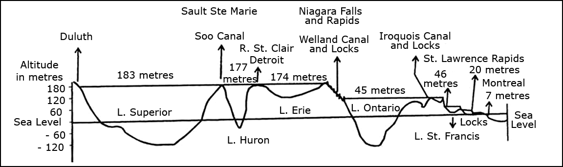
9.1 Name the river which is a part and parcel of this inland waterway.
9.2 What is the water level drop between Lake Huron and Lake Ontario ?
9.3 Name the two lakes having their bottom above the sea level. Marks:3View AnswerAnswer:
9.1 It is St. Lawrence. 9.2 The water level drop between the two is 132. 9.3 Lake Erie and Lake St. Francis