Geography: 2004: CBSE: [Delhi]: Set – II
To Access the full content, Please Purchase
-
Q1
On the given outline map of the world are shown four features.
Identify them and write their names on the lines given in the map. 2x1=2 (1) The country having the highest density of population. (2) The eastern terminal of Trans-Siberian Railway. (3) The largest copper producing country and (4) The largest city in Europe . 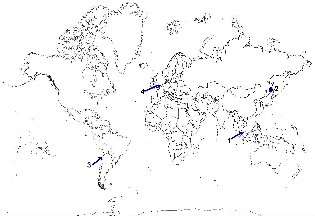
On the outline map of India provided, locate and label the following with appropriate symbols: (i) The state having the lowest sex-ratio. (ii) Eastern terminal of East-West corridor and super highway. (iii) The biggest refinery of India . Marks:5View AnswerAnswer:
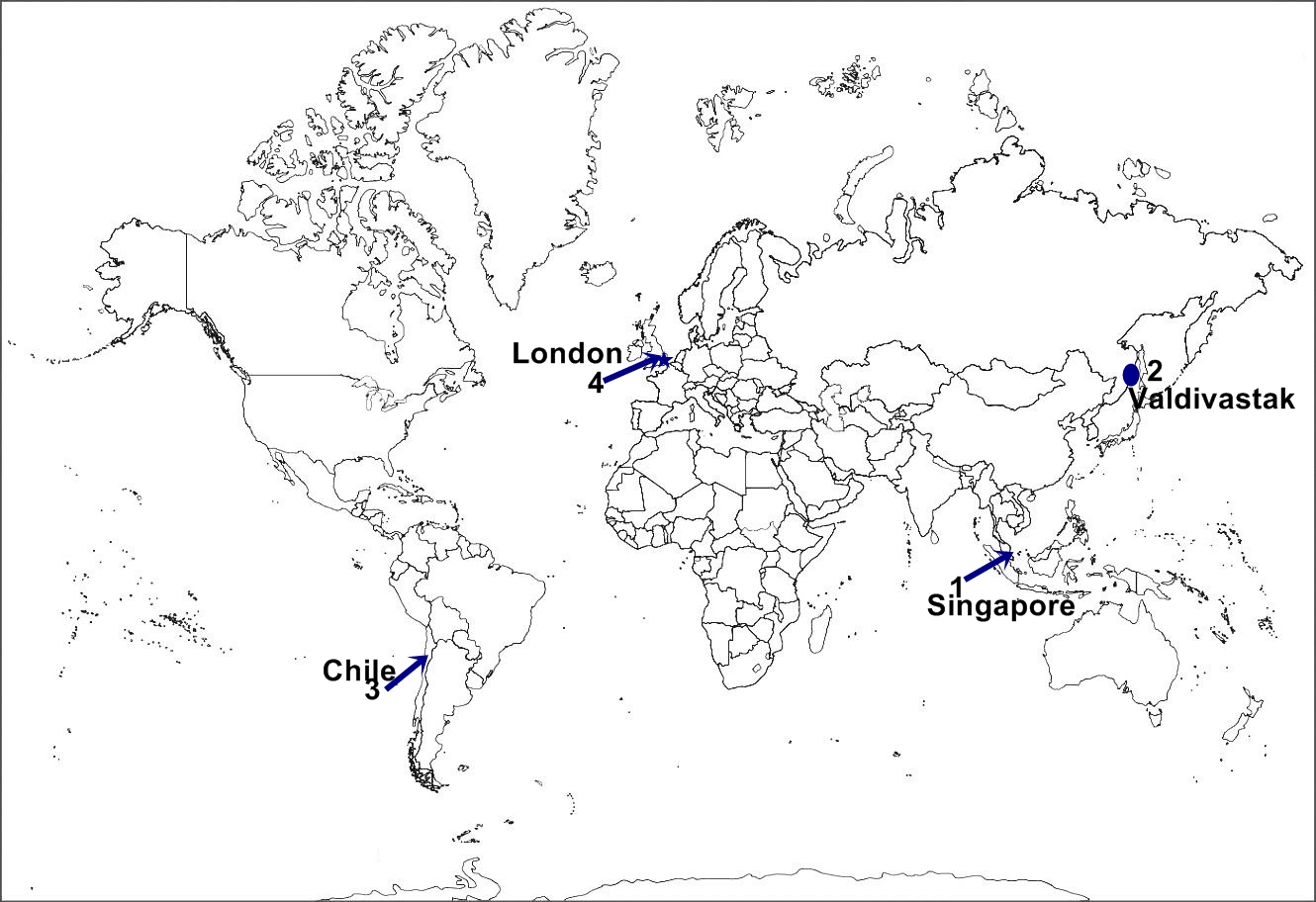
(1) Singapore (2) Valdivastak (3) Chile (4) London 
(i) Uttar Pradesh (ii) Silchar (iii)
Jamnagar -
Q2
Why does intensity of cropping vary from state to state? Explain three reasons with examples. 1+1+1=3 Marks:3View AnswerAnswer:
Intensity of cropping varies from state to state. Several factors are responsible for the variation of crop intensity among the states in India . It can be explained by the following points: Irrigation facilities: If a state has enough amount of water available for irrigation purpose, it will have high intensity cropping. Punjab and Haryana have high intensity of cropping because irrigation facilities are available from the five ever flowing rivers. Use of HYV seeds: The use of HYV seeds is another reason for the variation of crop intensity among the states. The states where HYV seeds are introduced, the crop intensity is high, for eg.it includes states like Punjab and Haryana. Use of chemical fertilizers: The introduction of fertilizers also increases the intensity of crops. The states where farmers are financially satisfied, they can afford to use fertilizers and thus have high intensity of cropping. -
Q3
In which two sections has the subject matter of ‘human geography’ been divided by Finech and Triwarth? State two features of each section. 1+1+1=3 Marks:3View AnswerAnswer:
Finech and Triwarth divided the subject matter of geography in the following two sections: (I) Physical or natural environment (II) Cultural or man-made environment The major features of the two are: (I) Physical environment: The two major features of physical environment are: (i) It consists of physical and natural features and phenomena like climate, drainage, natural resources like soil, water and mineral. (ii) All these elements and phenomena are solely controlled or governed by nature and man. (II) Cultural and man-made environment: Two features of cultural and man-made environment are: (i) It includes man made feature and phenomena on the earth such as population, settlement, as well as features associated with agriculture, manufacturing and transportation. (ii) The development of cultural environment is dependent on technology and skill that man uses to exploit the elements given to him by natural environment. -
Q4
Why is road transport considered more useful than other modes of transport in India ? Explain three reasons. 1+1+1=3 Marks:3View AnswerAnswer:
Road transport is considered more useful in India due to the following reasons: 1. Door to door services: In India, road transport is the only source of transportation which provides door to door service and flexibility of boarding and getting off at any place. 2. Connectivity with villages: In India , it holds the most dominant position because villages of India are connected with cities by roads only. Farmers use bullock carts on kachcha roads to reach cities. 3. Swift hauling for short distance: Most perishable items need rapid movement for short distances, so road transport is very important for swift hauling. -
Q5
What is ‘international trade’? Which are the two types of international trade? 1+1+1=3 Marks:3View AnswerAnswer:
The interchange of goods and services among the countries is called international trade. Two types of international trade are: (i) Bilateral Trade (ii) Multilateral Trade Bilateral Trade: When exchange of commodities and services takes place between two countries, it is called bilateral trade. Primary products are mostly exchanged with manufactured goods between two countries. Multilateral Trade: When goods and services are exchanged among a number of countries, it is called multilateral trade. U.S.A. and Europe are providing technical know how to set up industries to a number of developing countries.
-
Q6
State three ways in which natural resources help humans. 1+1+1=3 Marks:3View AnswerAnswer:
Natural resources are most important for the human beings. The three ways in which they help the human being are as follows: (i) They provide material, energy and favourable conditions for development. (ii) Air, water, land and forests are necessary for man’s survival and development. (iii) Natural resources are renewable and thus in order to conserve non-renewable resources, we can use them. -
Q7
What is rainwater harvesting? State any four objectives of rainwater harvesting. 1+2=3 Marks:3View AnswerAnswer:
Rainwater harvesting is a technology by which groundwater resources are increased and recharged by storing and collecting rainwater in sub surface water reservoirs. Objectives of rainwater harvesting: (i) It helps in meeting the ever increasing demand of water. (ii) It avoids flooding of roads and reduces wastage of water. (iii) It replenishes groundwater and raises the water level and supplements domestic water requirement. (iv) It reduces soil erosion and improves the quality of groundwater by reducing its pollution. -
Q8
Study the map given below and answer the questions that follow: 1+1+1=3
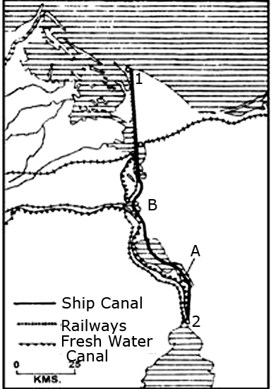
a. Name the two seas connected by the canal shown in the map. b. Name the two ports marked in the map by No. 1 and 2. c. Name the lakes shown by A and B. Marks:3View AnswerAnswer:
a. It connects Mediterranean Sea with Red Sea .
b. No. 1 is Port Said and No. 2 is Port Suez.
c. A is Great Bitter Lake and B is Timsa Lake. -
Q9
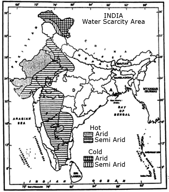
Study the map and answer the following questions: 1
1/2 x1 1/2 =3 10.1 Which arid area of northern part faces water scarcity? In which category (Hot and Cold) this area is placed?
10.2 Which arid area of north-western part faces water scarcity? In which category (Hot and Cold) this area is placed?
Marks:3View AnswerAnswer:
10.1 It is Jammu and Kashmir in the north, which is facing water scarcity. It is placed under cold category.
10.2 Rajasthan in the north-western part is facing water scarcity. It is placed under hot category. -
Q10
What is commercial livestock rearing? Write its four characteristics. 1+2=3 Marks:3View AnswerAnswer:
In commercial livestock rearing, animals are reared on extensive grasslands with modern scientific methods. Its main characteristics are: (i) Animals are reared at fixed ranches and are fed fodder crops and cultivated grasses. Animals do not move from one place to place. (ii) Emphasis is laid on genetic improvement, disease control and health care of animals. (iii) Every activity like cultivation of fodder crops, processing of milk, meat and packaging of milk and animal products is carried out mechanically and on scientific lines. (iv) Commercial grazing is carried in prairies in U.S.A. , Western Canada and Central Mexico , Pampas of Brazilian Plateau, Lanos of Venezuela, Veldt of South Africa and temperate grasslands of Australia and New Zealand .